A map from 1513, twenty earlier charts, and one question: who owns what we know?
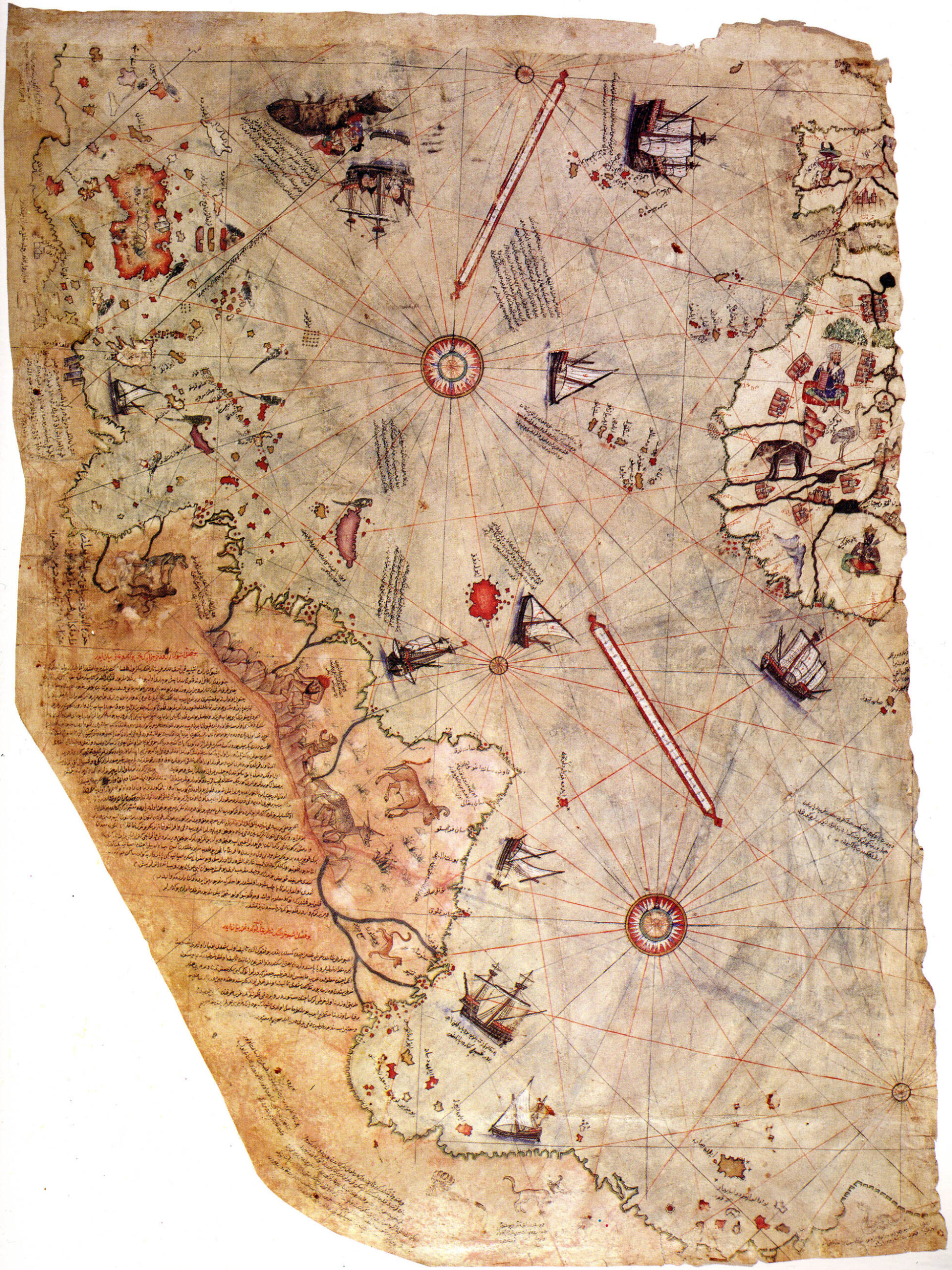
In 1929, during the reorganization of the collections at Topkapı Palace in Istanbul, a map resurfaced that no one had consulted for centuries. Drawn on parchment, it bears inscriptions in Ottoman Turkish and depicts part of the Atlantic, the western coasts of Europe and Africa, the Caribbean islands, and the eastern coastline of South America. The map is dated 1513. Its maker was Piri Reis, a navigator and cartographer of the Ottoman Empire. What makes it exceptional is not simply its age, or the relative accuracy with which it depicts territories Europeans had begun exploring only a few decades earlier. It is a statement written on the map itself: Piri Reis explains that he compiled it using some twenty earlier maps drawn from different traditions. Among them, he says, was a map by Christopher Columbus. This opens up a fascinating question. How can one map preserve information from documents that no longer exist? And what happens to knowledge when it passes from one person to another, from one language to another, from one civilization to another?
A Cartographer who did not start from scratch
Piri Reis was probably born in Gallipoli in the second half of the fifteenth century. He sailed with his uncle Kemal Reis, a corsair who later became a commander of the Ottoman fleet, gaining extensive experience of the Mediterranean. When he made his 1513 map, the world known to navigators was changing rapidly. Portuguese voyages had transformed knowledge of the African coasts and opened routes to the Indian Ocean. Spanish expeditions had reached the Americas. Maps were becoming navigational tools, but also political and commercial assets. Information circulated unevenly. Some was jealously guarded by monarchies and navigators; other information passed through merchants, sailors, prisoners, ambassadors, and intermediaries. Piri Reis worked within this network. His map belongs to the portolan-chart tradition, characterized by dense networks of directional lines, coastal references, and place names. Yet it is not a simple reproduction of an existing model: it gathers and reorganizes representations of the world developed in different settings. In its inscriptions, the author mentions Arab and Portuguese charts, as well as one attributed to Columbus. He claims to have brought them onto a common scale to produce a new representation. We do not know every document he had before him, nor can we verify every detail of the process he describes. We do know, however, that his work bears recognizable traces of different cartographic traditions. This is perhaps the most interesting point: Piri Reis does not conceal his dependence on the work of others. He states it openly.
Columbus’s lost map
We possess no map drawn by Christopher Columbus himself that can be securely identified with the one mentioned by Piri Reis. Yet the reference is not merely a legend invented centuries later. It appears in the document of 1513. The historian of cartography Gregory C. McIntosh has systematically studied the inscriptions, place names, and shapes of the landmasses depicted. His analysis suggests that some features of the Caribbean section probably derive from a map made by Columbus, or under his supervision, around 1495–1496. The hypothesis is significant, but it must be stated precisely. It is documented that Piri Reis claimed to have used a map by Columbus. Comparative cartographic evidence makes it plausible that some information did indeed come from that tradition. What is not possible is to identify the lost document physically or reconstruct it in its entirety. The distinction is fundamental. The Ottoman map does not give us a vanished original as if it were a photograph. Instead, it offers indirect evidence transformed through successive stages of transmission. In places, moreover, it preserves not only geographical information but also the errors and beliefs of earlier navigators. The depiction of Cuba, for instance, reflects Columbus’s belief that the island formed part of the Asian mainland. This detail is revealing: when knowledge is passed on, discoveries are not the only things that travel. Misconceptions travel too.
Memory is not a copy
Let us imagine Piri Reis at work for a moment. Before him lie charts made at different times, using different techniques, by men who had not necessarily seen the same places. Some describe coasts explored firsthand. Others contain secondhand information. Still others preserve imaginary features or older geographical traditions. To compose a new map, the cartographer must select, compare, and adapt. The result is identical to none of his sources. This process reveals a general principle: transmitting knowledge is never simply a matter of preserving it. It also means transforming it. One map may preserve the memory of another while changing it in the very act of incorporating it. We need not imagine Piri Reis as a theorist of knowledge. We have no evidence that he attributed to his work the philosophical significance we can recognize in it today. His practice nevertheless offers a concrete example of what happens when information produced separately is brought together in a new structure. Knowledge can survive even when its original medium does not. It can be transmitted without preserving the name of its creator. It may even become more useful precisely because someone has removed it from its initial context and compared it with other knowledge. But every transfer carries a risk: something is lost, something changes, something is interpreted. Memory is not a static storehouse. It is a reconstruction continually exposed to error.
A geography without cultural borders
The 1513 map is often presented as a curiosity of Ottoman history. But that description risks diminishing its significance. Piri Reis was not working on the fringes of an exclusively European geographical world. He participated in a network of exchanges spanning the Mediterranean and connecting Islamic, European, and other Mediterranean traditions. The historian Karen C. Pinto has drawn attention to iconographic elements linking the map to the Islamic geographical tradition. Other studies have shown that some animal figures reflect medieval European and Near Eastern visual repertoires, while others may derive from reports gathered on Atlantic voyages. Geographical observations, nautical conventions, stories, exotic animals, and images inherited from earlier traditions thus coexist on the same parchment. Not everything has the same evidentiary value. But everything helps tell the story of how the world was known and represented. This distinction also helps prevent a naive reading of the map: we are not looking at a photograph of the Earth in 1513. We are looking at a historical synthesis of the information available to a cartographer, his sources, and his choices. In this sense, the document depicts two geographies: that of places and that of knowledge.
The false mystery of Antarctica
The Piri Reis map has also acquired a much less rigorous afterlife. According to a theory that became popular in the twentieth century, the southern portion of the parchment depicts Antarctica, even showing the shape of the continent concealed beneath its ice. This has given rise to hypotheses about prehistoric civilizations with extraordinary geographical knowledge, lost maps of immense antiquity, and—in the more fanciful versions—extraterrestrial intervention. The problem is that no convincing evidence supports these interpretations. The southern coastline can be understood in the context of sixteenth-century depictions of South America, their distortions, and the geographical conceptions of the period. The alleged matches with Antarctica depend on selective comparisons that do not withstand systematic cartographic analysis. The map contains inaccuracies, discontinuities, and territories whose identification remains disputed. But an anomaly does not automatically prove the existence of impossible knowledge. Indeed, the genuine historical puzzle is far more interesting than the fantastical one: how did an Ottoman navigator manage to collect and combine information from such diverse geographical networks in 1513? Answering that question requires no vanished civilizations. It requires us to reconstruct the routes along which knowledge traveled.
The book of the sea
The 1513 map was not Piri Reis’s only major achievement. In subsequent years he compiled the Kitab-ı Bahriye, or Book of Navigation, first completed in 1521 and then expanded in a version presented to Sultan Suleiman the Magnificent in 1526. The work describes Mediterranean coasts, islands, landing places, inlets, navigational hazards, and the characteristics of harbors, accompanying this information with detailed charts. Here the relationship between firsthand experience and inherited knowledge takes another form. Piri Reis had sailed extensively in the seas he described. But here, too, he did not rely exclusively on his own experience. Scholars have identified parallels with other cartographic traditions, including Venetian island books. It is hard to imagine a more concrete example of the interplay between personal observation and the knowledge of others. A sailor recognizes a coast because he has seen it. A cartographer compares it with an earlier depiction. An author describes it so that others may reach it without ever having visited. Individual experience becomes knowledge that can be passed on. And the moment it is transmitted, it ceases to belong only to the person who lived it.
What remains
Only a fragment survives of the 1513 world map. We do not know for certain what happened to the missing portions. Many of the charts Piri Reis used have not survived. Some are known only because the cartographer said they existed; others can be traced indirectly. Yet more than five centuries later, that fragment still speaks to us. Not because it holds a secret geographical truth, but because it makes visible a process that usually remains hidden: the construction of knowledge through the work of different people, separated by time, language, and geography. A Portuguese chart can leave its trace in an Ottoman work. An observation made in the Caribbean can pass through a copy and reappear on parchment drawn in Gallipoli. An error can survive alongside a discovery. Knowledge crosses borders, but it does not emerge unchanged. Piri Reis gives us more than an incomplete picture of the world. Perhaps unintentionally, he gives us a picture of how human beings construct their collective memory. We do not know everything our predecessors knew. But some of what we know exists because someone before us preserved, copied, corrected, or transformed what they had learned from others. The world’s memory is not made up solely of works that have survived. It also consists of lost works that continue, invisibly, to live within other works
Sources and Documentary Verification
These are the main sources used for the first draft, with their differing evidentiary weight.
- 1. UNESCO, The Piri Reis World Map (1513). Entry in the Memory of the World programme, which inscribed the map in 2017. Confirms the date, its rediscovery in 1929, its preservation at Topkapı, and the document’s historical importance. Scheda UNESCO.
- 2. Gregory C. McIntosh, The Piri Reis Map of 1513, University of Georgia Press, 2000. The central specialist reference for inscriptions, place names, cartographic sources, the Columbian tradition, and criticism of Antarctic interpretations. I checked the publisher’s description and available chapter excerpts, not the entire volume. Scheda e capitoli su JSTOR.
- 3. Svat Soucek, “Islamic Charting in the Mediterranean,” in The History of Cartography, vol. 2, book 1, University of Chicago Press. A fundamental source on Ottoman nautical context and the passage in which Piri Reis describes compiling his charts. Capitolo in PDF.
- 4. Karen C. Pinto, “Searchin’ His Eyes, Lookin’ for Traces,” Journal of Ottoman Studies, 39, 2012, pp. 63–94. Explores iconographic connections between the Piri Reis map and Islamic cartographic traditions. Studio accademico.
- 5. Marco Masseti and Cecilia Veracini, “The zoomorphic representations of the Pîrî Reis map (1513),” Anthropozoologica, 51(1), 2016, pp. 41–54. An analysis of the animal figures and their iconographic origins. Articolo scientifico.
- 6. “The Cartographer Sets Sail: Eyewitness Records and Early Modern Maps,” Culture & History Digital Journal. Useful for comparing firsthand experience, cartographic compilation, and Venetian sources for the Kitab-ı Bahriye Articolo.
- Library of Congress, Book on Navigation. Scheda e manoscritto digitalizzato del Kitab-ı Bahriye, in una copia più tarda. Consente di documentare la tradizione manoscritta e la ricchezza cartografica dell’opera. Library of Congress Manoscritto digitalizzato.
Epistemological assessment
Documented Facts. The map dates from 1513; it was rediscovered in 1929; a fragment survives; it contains inscriptions describing the sources used; Piri Reis also produced the Kitab-ı Bahriye, in versions dated 1521 and 1526. Plausible Reconstructions. The indirect presence of a Columbian chart, perhaps dating from the second voyage; the specific routes by which Piri Reis obtained some of his sources; and the extent of his reliance on particular European and Islamic models. These are hypotheses supported by comparative analysis, not absolute documentary certainties. Interpretations Lacking Convincing Evidence. A scientifically accurate depiction of Antarctica beneath its ice, derivation from vanished technologically advanced civilizations, or extraterrestrial knowledge. Cartographic anomalies do not constitute evidence for these claims
Final note
The 1513 map of Piri Reis is an authentic historical document, as are the cartographer’s recorded statements about his sources. His reference to a chart attributed to Christopher Columbus is attested in the inscriptions, but the identification and reconstruction of that lost document remain subjects of research.
Other connections, such as links to specific European and Islamic cartographic traditions, rest on historical and iconographic comparisons: reasoned reconstructions whose every step cannot always be demonstrated. Interpretations claiming that the map depicts ice-free Antarctica, or reflects knowledge from vanished technologically advanced civilizations, lack convincing evidence. Isobare was also created to distinguish these different levels: what documents establish, what we can reasonably hypothesize, and what, however fascinating, is not supported by the evidence.